As an Amazon Associate, BrokeMountain earns from qualifying purchases. We did not test these units in person; this guide is based on Garmin specifications, independent test results and hiker feedback.
Phone mapping apps have come a long way, but a dedicated handheld GPS is still the most reliable navigation tool for serious hikes. It is built to survive drops, rain and cold, its battery can last for days or weeks, and it keeps working long after a phone has died. For multi-day treks, off-trail routes and remote areas with no cell signal, a handheld GPS is a smart investment in safety.
This guide compares the best handheld GPS units for hiking, from budget eTrex models to the feature-packed GPSMAP 67 and 67i, and explains how to choose and use one.
Quick Picks
- Best overall: Garmin GPSMAP 67
- Best with satellite SOS and messaging: Garmin GPSMAP 67i
- Best mid-range with sensors: Garmin eTrex 32x
- Best simple topo GPS: Garmin eTrex 22x
- Best budget and battery life: Garmin eTrex SE
- Best touchscreen eTrex: Garmin eTrex Touch
1. Garmin GPSMAP 67
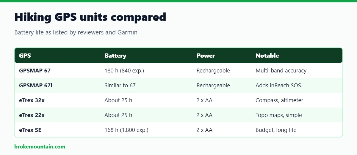
Best overall. The GPSMAP 67 is Garmin’s flagship button-operated handheld, and OutdoorGearLab named it the best handheld GPS it tested, scoring it highest for navigation. It lists up to 180 hours of battery in standard GPS mode and 840 hours in expedition mode, weighs about 8.1 ounces, and charges via USB-C. Multi-band GNSS support improves accuracy in deep canyons and dense forest, where single-band units can drift.
Pros: excellent accuracy, very long battery life, rugged buttons that work with gloves, big 3-inch screen.
Cons: heavier and pricier than eTrex models; no satellite messaging.
Check the Garmin GPSMAP 67 on Amazon
2. Garmin GPSMAP 67i
Best with satellite SOS and messaging. The 67i combines the GPSMAP 67’s navigation with Garmin inReach satellite technology for two-way messaging, location sharing and interactive SOS. GearJunkie picked the GPSMAP 67i as its best handheld GPS for the backcountry and off-trail, listing 180 hours of battery in standard mode and 840 hours in expedition mode. You need an active Garmin satellite subscription to use the messaging and SOS features.
Pros: navigation and satellite communication in one device, long battery life.
Cons: expensive, plus a monthly or annual subscription.
Check the Garmin GPSMAP 67i on Amazon
3. Garmin eTrex 32x
Best mid-range with sensors. The eTrex 32x is a compact, AA-powered handheld with a colour screen, preloaded topo maps, a three-axis compass and a barometric altimeter. GearJunkie lists about 25 hours of battery life from two AA batteries, a weight of 5 ounces and IPX7 water resistance. The compass works even when you are standing still, and the altimeter gives more accurate elevation and weather trends than GPS alone.
Pros: compass and altimeter, light, swappable AA batteries.
Cons: older GPS and GLONASS only, so less accurate than multi-band units; slow interface.
Check the Garmin eTrex 32x on Amazon
4. Garmin eTrex 22x
Best simple topo GPS. The eTrex 22x offers the same colour screen and preloaded TopoActive maps as the 32x, without the compass and altimeter. GearJunkie lists 25 hours of battery from two AA batteries, a 2.2-inch screen, 8GB of memory and IPX7 water resistance, and praises its simple interface and good reception for the price. GearJunkie also notes that the 22x and 32x use only GPS and GLONASS, so they are less accurate than newer units that track five or more satellite systems.
Pros: affordable, simple, topo maps included.
Cons: no compass or altimeter; older satellite support.
Check the Garmin eTrex 22x on Amazon
5. Garmin eTrex SE
Best budget and battery life. The eTrex SE is a modern take on the classic budget GPS. Switchback Travel lists it at about $150, with a 2.2-inch screen, a weight of 5.5 ounces and an impressive 168 hours of battery life, or 1,800 hours in expedition mode. The trade-off is a simple monochrome display with no detailed topo maps; it is best for tracking, waypoints and breadcrumb navigation.
Pros: very long battery life, low price, modern multi-GNSS support.
Cons: no topo maps, basic screen.
Check the Garmin eTrex SE on Amazon
6. Garmin eTrex Touch
Best touchscreen eTrex. Garmin’s newer eTrex Touch brings a touchscreen to the compact eTrex line, and GearJunkie’s 2026 guide rates it as its best overall handheld GPS, scoring it highly for satellite reception. It suits hikers who are used to phone-style controls and want the reliability of a dedicated GPS in a small package. Touchscreens can be harder to use with thick gloves, so winter hikers may still prefer buttons.
Pros: intuitive touchscreen, compact, strong reception.
Cons: touchscreens are less glove-friendly than buttons.
Check the Garmin eTrex Touch on Amazon
Handheld GPS vs Phone vs Watch
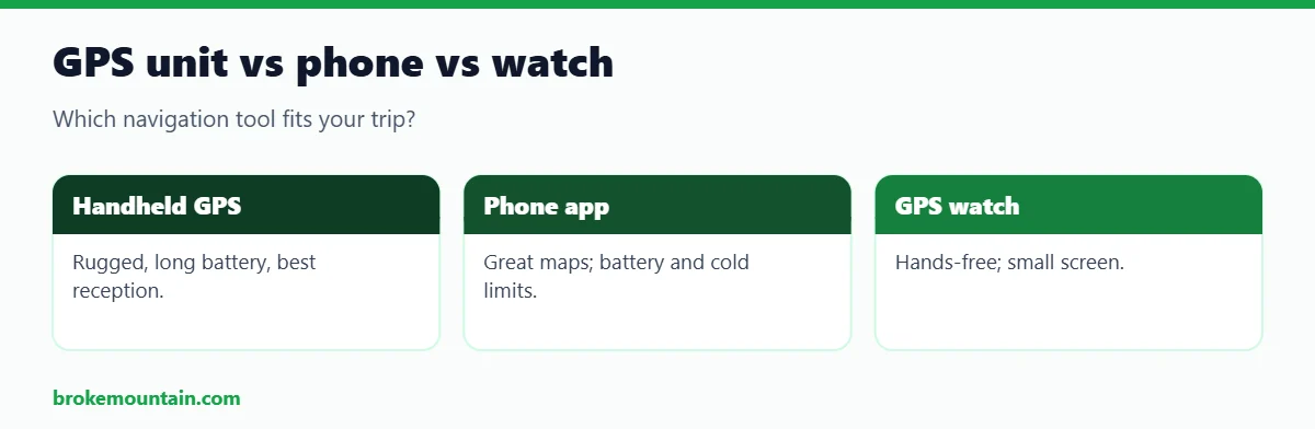
Handheld GPS units are rugged, waterproof, have the longest battery life, and often use replaceable AA batteries. They get excellent reception and keep working in cold weather.
Phone apps have beautiful maps and are easy to use, but batteries drain quickly with the screen on, cold weather shortens battery life further, and phones are fragile. A phone is a great backup, not ideal as your only navigation on remote trips.
GPS watches are hands-free and handy for checking position and following a route, but their small screens make map reading harder. See our guide to the best GPS mountain bike computer if you also ride trails.
How to Choose a Hiking GPS
Battery type and life
Rechargeable batteries are convenient and last longer per charge on newer models. AA batteries can be swapped in the field, which is helpful on long trips without charging options.
Maps
Preloaded topo maps show trails, contours and terrain. Budget units without maps are fine for tracking and waypoints, but harder to use for route-finding.
Sensors
A three-axis compass and barometric altimeter give accurate heading and elevation, which helps in fog or dense forest.
Satellite systems
Newer units track several satellite systems (GPS, GLONASS, Galileo and more) and some use multi-band signals, which improves accuracy in tough terrain.
Satellite messaging
If you hike solo or in remote areas, a unit with inReach, or a separate satellite messenger, lets you send messages and call for help without cell signal.
Buttons vs touchscreen
Buttons work with gloves and in rain; touchscreens are faster for browsing maps in fair weather.
How to Prepare Your GPS Before a Hike
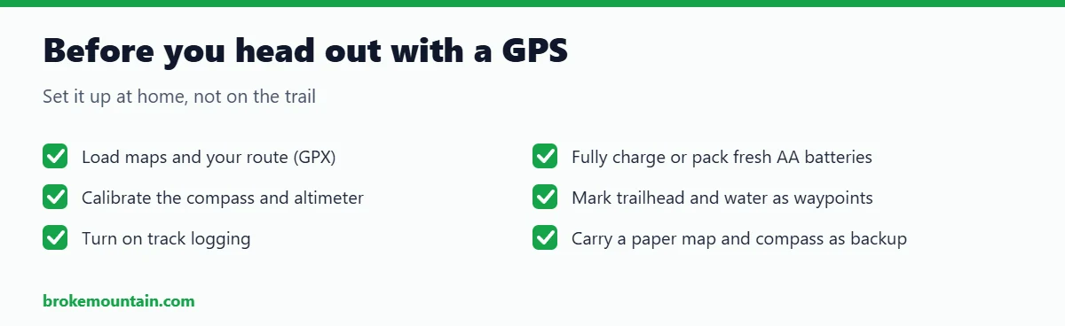
- Load your route: download a GPX track from a trusted source or plan one in Garmin Explore, then transfer it to the device.
- Charge or pack batteries: charge fully, or pack fresh lithium AA batteries, which last longer in cold weather.
- Calibrate sensors: calibrate the compass and set the altimeter at a known elevation.
- Mark key waypoints: trailhead, junctions, water sources and campsites.
- Turn on tracking: a recorded track lets you retrace your steps if you get lost.
- Practise at home: learn the menus before you rely on them on the trail.
Always carry a paper map and compass as a backup, along with other essentials like a reliable headlamp and a way to treat water, such as one of the best water filters for backpacking.
Understanding GPS Accuracy
Handheld GPS units are typically accurate to within a few metres under open sky. Accuracy drops in deep canyons, under thick tree cover and near tall cliffs, where satellite signals bounce or are blocked. Newer units help in three ways: they track more satellite systems at once (such as GPS, GLONASS, Galileo and others), some receive multiple frequency bands from each satellite, and they process signals faster. If you often hike in narrow valleys or dense forest, a multi-band model like the GPSMAP 67 is worth the extra cost.
Your settings also matter. Turning on all available satellite systems improves accuracy at the cost of battery life, while expedition or power-saving modes record fewer points to stretch the battery. For most day hikes, the default setting is a good balance.
Maps and Routes: Getting the Most From Your GPS
- Preloaded topo maps: many Garmin units ship with TopoActive maps that show trails, contours and points of interest.
- Satellite imagery: some models can download satellite images, which help when trails are faint or overgrown.
- Custom routes: plan routes on a computer or phone app and send them to the device before you leave.
- Track back: use the recorded track to retrace your path to the trailhead if you lose the trail.
- Waypoints: mark water sources, campsites and junctions so you can navigate back to them.
Batteries and Cold Weather
Cold weather drains batteries quickly. Lithium AA batteries perform much better than alkaline in the cold and weigh less, making them the best choice for AA-powered eTrex units. For rechargeable units, carry a small power bank and keep the GPS in an inside pocket overnight. Dim the screen, shorten the backlight timeout, and switch to expedition mode on long trips to stretch battery life. See lithium AA batteries.
Who Needs a Handheld GPS?
A handheld GPS makes the most sense for backpackers on multi-day trips, hikers who go off-trail or above treeline, hunters and anglers in remote areas, search and rescue volunteers, and anyone who explores places with no cell coverage. For casual day hikers on busy, well-marked trails, a phone app with offline maps and a small power bank is usually enough. If you are building a kit for longer trips, our guide to the best hiking daypacks under $100 covers packs with room for navigation tools and essentials.
Common GPS Mistakes to Avoid
- Relying on one device: electronics fail. Always carry a paper map and compass, and know how to use them.
- Not checking batteries: start every trip with a full charge or fresh batteries, plus spares.
- Following the line blindly: GPS tracks can be out of date. Use your eyes, trail markers and common sense, especially near cliffs and water crossings.
- Skipping updates: update firmware and maps at home before a big trip.
- Keeping it buried in a pack: clip the GPS to a shoulder strap so it has a clear view of the sky and is easy to check.
Frequently Asked Questions
Do I need a handheld GPS if I have a phone?
For short, well-marked day hikes, a phone app is usually enough. For remote, multi-day or off-trail trips, a handheld GPS is more reliable thanks to its battery life, toughness and reception.
Do handheld GPS units need a subscription?
Basic navigation does not. Units with inReach satellite messaging, like the GPSMAP 67i, need an active satellite subscription for messaging and SOS.
Which is better, GPSMAP or eTrex?
GPSMAP models have bigger screens, better accuracy and longer battery life. eTrex models are smaller, lighter and cheaper. Choose based on how remote your hikes are and your budget.
Can a handheld GPS work without cell service?
Yes. GPS receivers use satellites, not cell towers, so they work anywhere with a view of the sky.
Are rechargeable or AA batteries better?
Rechargeable units often last longer per charge, while AA units let you carry spares for long trips. Lithium AAs work best in cold weather.
Is the GPSMAP 67 worth it over an eTrex?
For frequent backcountry hikers, yes: it offers better accuracy in difficult terrain, a larger screen and far longer battery life. Casual hikers will be well served by an eTrex.
Can I use a handheld GPS for geocaching?
Yes. Most Garmin handhelds support geocaching, letting you load caches and navigate to them, and some show live geocache updates when paired with a phone.
How long do handheld GPS units last?
Many hikers use the same Garmin handheld for five to ten years. Keep firmware updated and replace the battery or unit if runtime drops sharply.
Final Verdict
The Garmin GPSMAP 67 is the best handheld GPS for most serious hikers, with top accuracy and huge battery life. Choose the GPSMAP 67i if you want satellite messaging and SOS built in, the eTrex 32x for maps plus compass and altimeter in a light package, the eTrex 22x for simple topo navigation, the eTrex SE for budget and battery life, and the eTrex Touch if you prefer a touchscreen.
Browse handheld hiking GPS units on Amazon

Hi, I am Emam Hasan — founder and editor of BrokeMountain. I oversee this blog’s hiking, camping and outdoor gear guides, making sure every article is well-researched, accurate and genuinely helpful for your time on the trail. Enjoy it!